Search Instagram by location!
3 Simple ways to find photos by location
3 Simple ways to find photos by location
To understand how searching Instagram by location works, require to understand the Instagram location tagging.
One of the Instagram features, is to add location information to the photo, in order for people viewing a photo will know where was the photo taken.
Instagram provides two options to add location information to a shared photo:
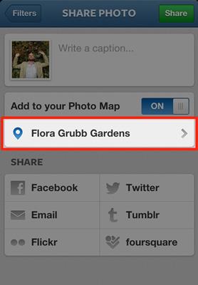
1. Add to photo map - Geotag
Instagram geotag embeds into the photo the latitude and longitude at which the photo was taken.
If when sharing a photo in the Instagram application the "Add to Photo Map" switch is turned on, it'll geotag the photo.
2. Add location - Tag a location
Tag location embeds into the photo the location latitude and longitude and the location name.
When the "Add to Photo Map" switch is on, it is possible to tag a specific location to the photo. Tapping the "Name This Location" option, opens a list of places found by the Instagram application to choose from.
The places in the list are Foursquare places near the user location.
Currently Instagram uses the Foursquare database to find the places. But we need to keep on tracking, and see if Instagram will replace Foursquare by Facebook places?
The Instagram location tagging is making it possible to search the Instagram database for all the photos geotagged to a specific place.
3rd party website or application can use Instagram Application Programming Interface (API) to pull photos by location.
This web based tool uses Instagram's API to search for photos with places close to a requested geographic location.
To request a geographic location you have three options:
1. Type a name or an address and select one of the suggested results.
2. Click on any place of interest on the map.
3. Click on the "find my location" button for your geographic location.
When requesting a geographic location, the search tool starts a search process. The search is done in two steps:
Step 1. Find places near the geographic location
The search tool sends the latitude and longitude and search distance to Foursquare database, using the Foursquare API. Foursquare API returns a list of places near the requested latitude and longitude. The search distance can be set by the user or the default distance of 500 meters is used.
Step 2. Get photos tagged with places
The search tool requests from Instagram tagged photos of each place, using the Instagram API. Instagram pulls the latest photos for each place and sends them via the API to the search tool.
When the search process ends a list of places with 3 photos tagged to each place is displayed.
If you would like to view additional photos of a specific place, simply click on it.
Enjoy!